Kilmadock
Community
Plan
Doune
Deanston
Buchany
Argaty
Workshops:
Following on from the initial community views surveys, the next step in creating a plan are workshop events looking at some of the big challenges for the community in the next decade.
On this page, you’ll find the main content on this topic presented at the workshops. Each topic has feedback activities, use the link to the feedback form to take part in these.
Menu
Feedback Form for all topics
Walking & Cycling
River Teith Footbridge
The Current Bridge
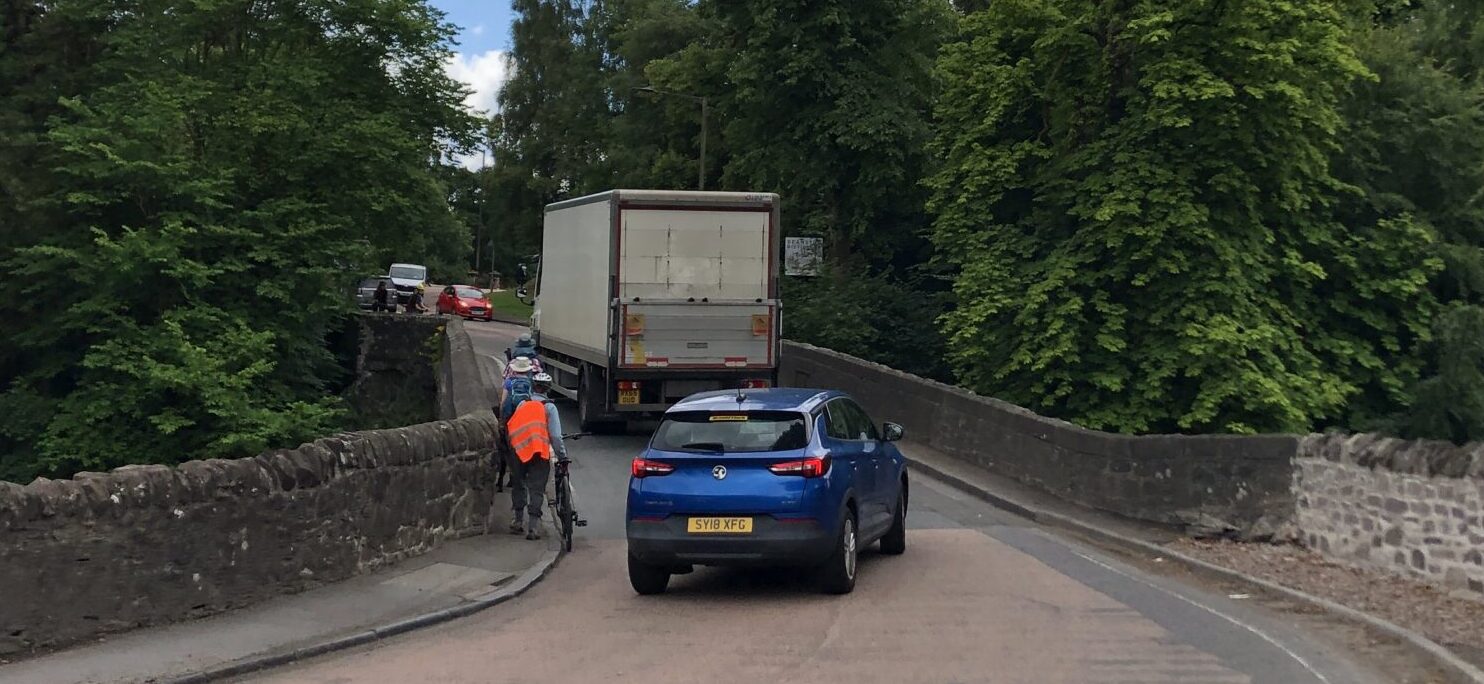
Originally constructed in 1535 (and widened in 1866), the Bridge of Teith provides a crossing over the River Teith for the A84 trunk road between Stirling and Callander. From parapet to parapet, the bridge deck is just over five metres wide.
On each side of the bridge, are what appears to be pavements of varying width (approximately 300mm on each side). While this can be used by pedestrians to cross the river, this is often alongside close passing two-way traffic, bringing safety issues. It is also not accessible. The Disability Discrimination Act recommends a minimum width of 1200mm for a footway.

Comments from Community Views survey:
“It’s difficult to walk across this bridge either just as a walk, or with children, a pram or dog. The road is super busy and the pavement super small. Living in Deanston it is the only access to Doune so it is a stressful part of getting there.”
“Crossing River Teith bridge on foot is stressful due to proximity of traffic (often speeding).”
“Teith bridge, very narrow footpath, particularly unpleasant to cross if large vehicle crossing too, in either direction. Can’t cross with our dog, too intimidating. The walking distance into Doune is not an issue, the bridge is.”
What’s the solution?
The road layout of the bridge could be changed, accommodating a wider footpath with a single carriageway. This would impact the flow of traffic, causing queues of idling vehicles, and would also be relying on an almost 500 year old structure as the only crossing connecting the community across the river.
Another solution is a traffic-free separate bridge over the Teith for walking, cycling and wheeling. This idea was the most suggested in this summer’s Community Views and Walking, Cycling and Public Transport surveys.
Every bridge design has design and structural challenges to overcome. Any new bridge crossing the Teith faces:
- A significant span of at least 50 metres.
- The proximity of two heritage conservation areas.
- The River Teith’s Special Area of Conservation designation.
- Ensuring onward walking routes (on both sides) are accessible.
We’ve been here before
A separate crossing over the River Teith isn’t a new idea. As traffic levels (and size) have increased in the past thirty years, the community has looked at how a safe crossing could be created.
For example a feasibility study in 2003/4 produced a location and design for a footbridge at Deanston. Clearly, the designs failed to move any further forward to reality.
While the need has always been there, the necessity has only increased. The closure of Deanston Shop this year in particular makes access more critical. The drive in government policy to encourage sustainable transport makes the case even stronger.

Design for 90 metre span bridge at Deanston Village from 2004
What can we do now?
Detailed work will need to be completed to determine a design that can deliver a footbridge to provide a safe crossing for walking, cycling and wheeling.
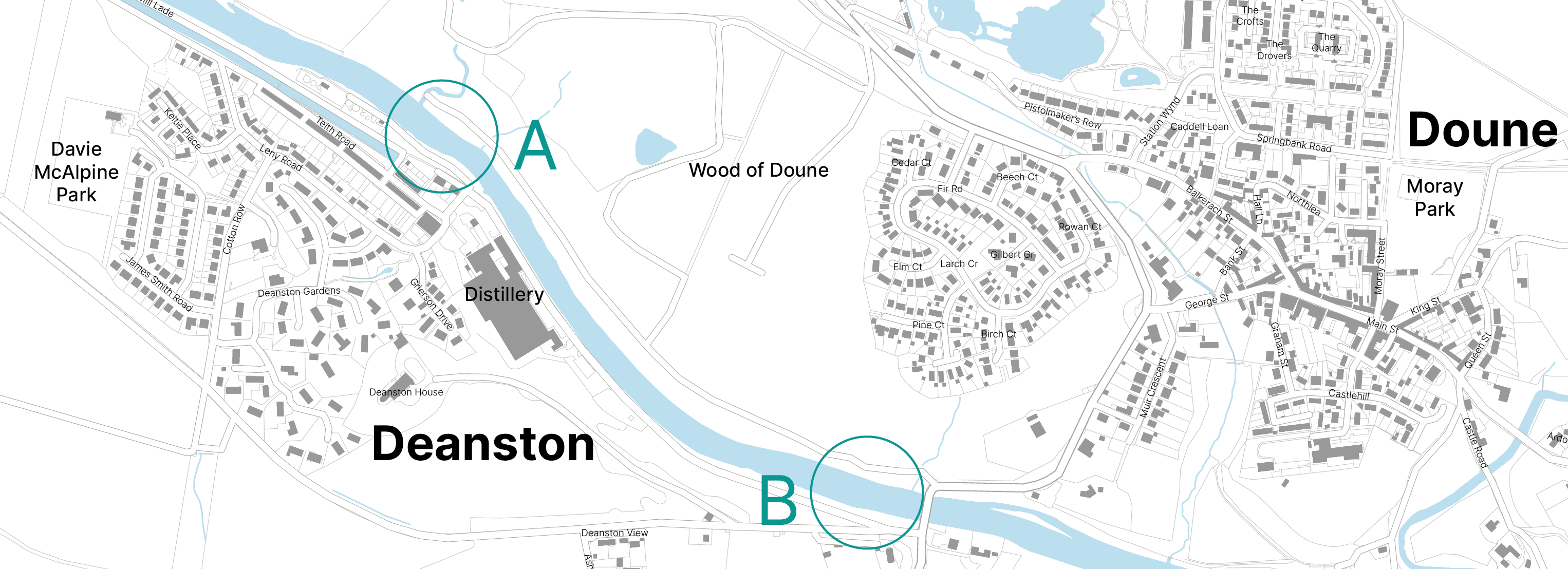
A number of locations for a bridge crossing have been considered before. The 2003/4 study narrowed down to two main sites, eventually settling on one between Deanston village and Wood of Doune woodland. However, there was by no means a consensus on that location at the time, almost twenty years have passed, and both villages are now much larger.
While we won’t be able to confirm exact locations until bridge designers are put to work and undertake site investigations. We can start work on building a new consensus on the preferred location of a new bridge.

Feedback activity
What are the Pros and Cons of each potential bridge location?
Path Developments
One of the summer surveys asked people to rate the quality of walking and cycling facilities locally between 1 and 7 (with seven being the highest). The results had walking rated highly, and cycling slightly lower.
In responses to the survey, people suggested a number of path improvements to make it easier and more enjoyable to walk and cycle locally. In particular the ability to go on more connected or ‘circular’ routes.
Shown on the map are the suggested path routes improvements.
Key to path types
Roadside Pavement
Traffic-free sealed surface
(e.g. railway path towards Dunblane)
Bound gravel path
(e.g. accessible paths at Doune Ponds)
Natural path
(e.g. path by Ardoch and Teith south of Doune Castle)
On-road section
Feedback activity
Review the proposals
Which would you prioritise?
Links to other topics
Community Action
Development
Energy
Future Deanston
Parking in Doune
Public Transport
Roads
Walking & Cycling
Workshops Homepage
Acknowledgements
On behalf of the community and in partnership with Kilmadock Community Council, Kilmadock Development Trust is guiding the process to create the plan. A number of other organisations are supporting the Community Plan development, for more information click here.

